All official European Union website addresses are in the europa.eu domain.
See all EU institutions and bodies
An official website of the European Union | How do you know?
Environmental information systems
EN

Assessing areas at risk of significant flooding, mapping flood extents, and identifying exposed assets and populations are essential for implementing coordinated and effective measures to reduce flood impacts, particularly in the context of climate change.
In the last years, flood management has shifted from pure protection against floods to the integrated management of flood risks. The EU Floods Directive requires Members States to develop Flood Risk Management Plans (FRMPs) coherently with the river basin management plans prepared under the Water Framework Directive. In this process, countries are called to evaluate flood risk on a river catchment scale, compile maps of flood prone areas, and inform local communities about these risks. Flood risk maps must cover the geographical areas that could be flooded in case of events with low (extreme event scenario), medium and high probability. For each of these events, the assessment should provide insights about the spatial extent of the flood, the water level and the velocity of the water flow. Flood risk maps are also very useful to communicate the exposure and vulnerability of flood prone areas to stakeholders. FRMPs are expected to address all relevant aspects of risk management, focusing on prevention, protection, preparedness and medium- and long-term planning. A combination of green and grey measures can be considered by flood risk management plans to mitigate flood related issues at the river basin scale. Both the Preliminary Flood Risk Assessment and the Flood Hazard and Risk Maps should make clear how climate change is included (or not) in the mapped scenarios. Flood risk management plans should be periodically reviewed and if necessary updated, taking into account the likely impacts of climate change on the occurrence of floods.
Relevant EU policies
Floods Directive, Water framework Directive
Advantages
- Improves coordination and collaboration among different sectors.
- Creates opportunity for establishing multi-level adaptive governance.
- Enables improved knowledge and awareness raising about risks and vulnerability to flooding.
Disadvantages
- Lack of legal instruments and mandates may hinder proper transboundary cooperation.
- Requires data availability, human and financial resources for flood mapping due to climate change.
Relevant synergies with mitigation
No relevant synergies with mitigation
Read the full text of the adaptation option
Description
According to the European Environment Agency, the consequences of pluvial, fluvial and coastal floods in Europe will overall worsen as a result of increases in intensity and frequency of flooding events due to climate change (EEA, 2016, 2020) By 2050 in a business-as-usual scenario, there could be a nearly fivefold increase in the annual economic losses resulting from floods in Europe (SWD(2019) 439).
Floods can be caused by: (i) heavy rainfall or meltwater, when the infiltration capacity of the soil is exceeded; (ii) rivers, when discharges overpass the capacity of water courses and water exits from usual riverbeds, spreading across the land, (iii) or storm-surges responsible for coastal flooding. Climate change is expected to increase the frequency and magnitude of extreme precipitation events, increase average and extreme temperatures (which are important for ice and snowmelt), rise sea level and intensify storminess with negative effects on extreme sea levels, thus further worsening the flooding risk. On the other hand, land use change and anthropological pressure on rivers are consistently impacting on the natural retention and drainage capacity of their catchment areas. This could be translated in a substantial increase of surface runoff and, consequently, in river peak discharge, which is expected to increase in various parts of north-western Europe (Blöschl et al., 2019). In low-lying coastal areas, the co-occurrence of high sea level and precipitation resulting in large runoff may cause compound flooding (Bevaqua et al., 2019).
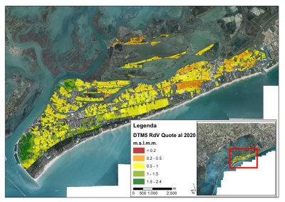
In the last years flood management has shifted from pure protection against floods to the integrated management of flood risks. In Europe, this shift is reflected in the EU Flood Directive, to be implemented in coordination with the EU Water Framework Directive (WFD). The Floods Directive requires Members States to develop Flood Risk Management Plans (FRMPs) coherently with the WFD river basin management plans. In this process, countries are called to evaluate flood risk on a river catchment scale, compile maps of flood prone areas, and inform local communities about these risks. Flood risk maps have to cover the geographical areas, which could be flooded in case of events with low (extreme event scenario), medium (e.g. those with a return period ≥ 100 years) and high probability. For each of these events the assessment should provide insights about the spatial extent of the flood, the water level and the velocity of the water flow. Flood risk maps are also very useful to communicate the exposure and vulnerability of flood prone areas to stakeholders.
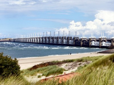
FRMPs are expected to address all relevant aspects of risk management, focusing on prevention, protection, preparedness and medium and long term planning, considering the characteristics of the particular river basin or sub-basin they deal with. A combination of green and grey measures can be considered by flood risk management plans to mitigate flood related issues at the river basin scale. Traditional flood (grey) protection solutions include dams, dikes, channels, storm surge defences and barriers in general. FRMPs may also include the promotion of green measures, including: sustainable land use practices, managed retreat from flood-prone areas, improvement of water retention through preservation and requalification of floodplains and wetlands, as well as controlled flooding of certain areas in the case of a flood event. Important solutions that can reduce the exposure of people and assets to floods also include awareness raising, early warning and the use of insurance schemes.
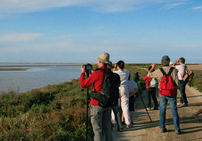
Stakeholder participation
The implementation of the EU Floods Directive requires the establishment of public participation mechanisms to ensure citizens’ involvement in the flood management cycle. All assessments, maps and plans prepared according to the Floods and WFD directives have to be made available to the public and uploaded to the common digital repository WISE, managed by the European Environment Agency.
FRMPs call for the input from different levels of institutions (national and regional) and from a large set of competencies. A variety of consultation channels with the public and stakeholders was used and, overall, a broad range of stakeholders was involved in the preparation of the first FRMPs (due by 2015). Among relevant stakeholders, the involvement of private subjects is also very important, as very often private properties are affected, directly or indirectly, by the implementation of the measures foreseen by the FRMPs.
Success and limiting factors
In some cases, the implementation of the Foods Directive has been beneficial in improving and strengthening the lack of coordination and collaboration among different sectors (e.g. flood protection, emergency planning, civil protection, spatial planning, insurance, river restoration), decision makers and stakeholders operating at different spatial scales. Despite such important effort, lack of coordination among different subjects and specifically between FRMPs and national adaptation strategies or plans is still an important gap in the shared management of the flooding risk.
As a result of the flood mapping process, the vulnerability of a wide number of European watercourses and coastal areas was mapped and assessed thus providing very useful knowledge for managing flood-prone areas. However, in the first cycle of FRMPs pluvial flood risk (due to heavy rainfall exceeding the soil infiltration capacity) was not considered equally relevant and its assessment was less detailed if compared to riverine and coastal risk evaluation.
Data availability and human and financial resources required to implement the flood mapping and assessment process, also considering climate change projections, are among the main constraints when dealing with FRMPs.
The Floods Directive adopts the river-basin scale as the unit of management and takes a multilevel approach to goal and standard setting, which is a positive attribute for adaptive governance, specifically in the light of climate changes. However, the lack of proper instruments formally embedded into the legal system that support cooperation mechanism might limit transboundary cooperation. In addition, differences in the legal frameworks, political viewpoints on flood risk management, and economic, social, and physical settings may hamper proper coordination and cooperation between scales.
Costs and benefits
The preparation of a Flood Risk Management Plan normally follows a 6-year cycle of planning, which requires the involvement of a wide variety of experts, including land and coastal planners, hydrologists, modellers, environmental scientists, engineers, etc. Resource and time efforts to be devoted to the plan elaboration depends on the scale of analysis, the strategic objectives and targets of plan and the availability of data and tools for their analysis. Given its importance, specific resources must be dedicated to stakeholder engagement and consultation, as well.
Legal aspects
The EU Flood Directive requires Member States to assess if areas close to watercourses and coastlines are at risk from flooding, to map the flood extent, assets and humans at risk in these areas, and to take adequate and coordinated measures to reduce this flood risk. The Directive also requires Member States to take in consideration the effects of climate change on the magnitude, frequency and location of floods, and therefore to integrate such effects into flood risk assessment, protection, prevention and preparedness.
Besides in the FRMPs themselves, the impacts of climate change and long term developments on the occurrence of floods is part 2 preceding steps of the planning process and of the reporting requirements: both the Preliminary Flood Risk Assessment and the Flood Hazard and Risk Maps should make clear how climate change is included (or not) in the mapped scenarios.
The Flood Directive shall be carried out in coordination with the Water Framework Directive, notably by flood risk management plans and river basin management plans being coordinated, and through coordination of the public participation procedures in the preparation of these plans. Both directives reinforce the rights of the public to access this information and to have a say in the planning process. A separate guidance document “River Basin Management in a changing climate” was produced to support this coordination.
Implementation time
The preparation of a flood risk management plan is based on three major steps each lasting 2 years: (i) preliminary flood risk assessment (PFRA); (ii) flood hazard and flood risk mapping, (iii) elaboration of the Flood Risk Management Plans (FRMP). The implementation time of the plan is highly dependent on the set objectives and targets and the related identified measures.
Lifetime
Flood risk management plans have to be reviewed every 6 years according to the Floods Directive. As far as implementation is concerned, lifetime of specific measures included in the plans depend on the measure typology, varying from months to decades.
References
COM (2025) 2 final - Commission report on the implementation of the Water Framework Directive (Third River Basin Management Plans) and the Floods Directive (second Flood Risk Management Plans). 04.02.2025.
SWD (2019) 439. Fitness check of the Water Framework Directive and the Floods Directive. 10.02.2019
ECA, (2018). Floods Directive: progress in assessing risks, while planning and implementation need to improve.
EEA (2016). Flood risks and environmental vulnerability. Exploring the synergies between floodplain restoration, water policies and thematic policies. EEA Report 1/2016.
Websites:
Published in Climate-ADAPT: Aug 31, 2016
Adaptation Option illustrations (3)

Related Resources
Language preference detected
Do you want to see the page translated into ?
Exclusion of liability
This translation is generated by eTranslation, a machine translation tool provided by the European Commission.
Exclusion of liability
This translation is generated by eTranslation, a machine translation tool provided by the European Commission.