All official European Union website addresses are in the europa.eu domain.
See all EU institutions and bodies
An official website of the European Union | How do you know?
Environmental information systems
EN

Ensuring an equitable use of the marine space for aquaculture, supporting the production also in changing climate and environmental conditions, while minimizing conflicts with other uses and achieving or maintain a good ecological status of marine waters.
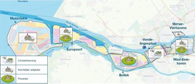
Embedded in the maritime spatial planning process, risk-based zoning for aquaculture identifies areas potentially suitable for farming, also referred as Allocated Zones for Aquaculture (AZA). This ensures systematic integration of aquaculture into marine areas already exploited by multiple uses. Zoning should include a complete risk analysis that identifies main threats for a successful production of farmed species. Climate-related risks also need to be considered, to ensure success in the aquaculture business, since this sector is vulnerable to several potentially catastrophic climate disturbances.
When broad zones suitable for marine aquaculture are defined, the siting step ensures that farms are placed in a location with proper characteristics that enable production. Through site selection, the biophysical attributes of a site are compared to the needs of the farmed species and to the functioning requirements of farms. Risk-based zoning and site selection is both needed in areas where aquaculture is beginning to develop and where aquaculture has already developed. It is also beneficial in areas where its relocation is constrained by environmental and climate issues as well as by conflicts with other uses.
Relevant EU policies
Maritime Spatial Planning (MSP) Directive, Strategic guidelines for a more sustainable and competitive EU aquaculture for the period 2021 to 2030, Common Fisheries Policy, Ocean Pact
Advantages
- Makes investment more attractive, if climate change challenges are considered.
- Reduces economic losses due to selection of sites unsuitable for adverse climate conditions and vulnerable to climate change.
- Supports more sustainable and competitive aquaculture.
- Supports ecosystem and biodiversity preservation if sustainable techniques are used.
Disadvantages
- May be hindered by the lack of data and modeling capacity that limits proper climate and environmental risk assessments.
- Requires specific skills and expertise in the use of spatial analysis tools.
- Requires considerable economic and human resources for risk modelling (software licences, training for using specific tools).
Relevant synergies with mitigation
No relevant synergies with mitigation
Read the full text of the adaptation option
Description
Spatial planning for marine aquaculture, including risk-based zoning and siting, is receiving increased attention, considering the increasing development of the aquaculture industry. It aims to ensure the most equitable use of the marine space for this activity, supporting production, minimising conflicts with other uses and maintaining environmental integrity.
Marine aquaculture zoning and siting through an ecosystem approach and considering climate variability and change is encouraged by FAO (FAO, 2018, FAO, 2017) as an important adaptation measure. Appropriate site selection supported by a flexible regulatory framework, is also suggested as adaptation strategy in case studies of the Horizon 2020-funded ClimeFish project, aiming to ensure that the increase in seafood production comes in areas and for species where there is a potential for sustainable growth, given the expected changes in climate. Risk-based zoning and siting can help avoiding areas particularly vulnerable to climate risks and selecting the most suitable areas for the cultured species, considering both the current state and the challenges posed by climate change in the medium-long term. The overall process allows minimizing possible economic losses that could derive from choices that do not take into account all risks and concerns.
Risk-based zoning and site selection is needed in areas both where aquaculture is beginning to develop and where aquaculture has already developed and its relocation is constrained by environmental issues and conflicts with other uses. A wide variety of spatial tools and models exists, as described in a dedicated FAO publication (FAO, 2017). New knowledge has been produced by the Aquaspace project (funded by the EU Horizon 2020 programme), which aimed to understand spatial and socio-economic constraints on the expansion of aquaculture and test tools to help overcome these constraints. Specifically, Aquaspace delivered a toolbox containing information on tools tested during the project, to help and support the purpose of making more high-quality space available for aquaculture. With the H2020 funded project TAPAS (Tools for Assessment and Planning of Aquaculture Sustainability), new research has been developing to promote and consolidate the environmental sustainability of the European aquaculture, also providing near-field models for site selection of aquaculture, using a series of existing, adapted and newly developed models.
Within the spatial planning process, the zoning step aims to identify broad areas potentially suitable for aquaculture, also referred as Allocated Zones for Aquaculture (AZA), in order to ensure integration of aquaculture into areas already exploited by other uses. Zoning should include a complete risk analysis identifying main threats to a successful production. Climate-related risks need to be taken into account as well to ensure success in the aquaculture business, considering that the sector is vulnerable to a number of potentially catastrophic climate disturbances. Climate risks include direct damages caused by severe waves, tidal and storm surges, as well as slow onset effects responsible for changing of physical-chemical conditions of seawater (e.g. increasing temperatures, acidification) and related indirect impacts such as disease diffusion, harmful algal blooms and hypoxia. Climate risks figure among other non-climate risks, related for example to the environment (pollution), health (biosecurity) and to social conflicts.
When broad zones suitable for marine aquaculture are defined, the siting step ensures that farms are located in a specific location with proper characteristics that enable a successful production. Through site selection the biophysical attributes of a site are compared to the needs of the selected organisms for culture and to the functioning requirements of farms. This assessment should include a review of local climate conditions (historical data), of risks posed by climate variability (e.g. storms) and of long term trends (e.g. rising temperature and change in salinity). The whole process of zoning and siting aims to minimise conflicts with other sectors and adverse impacts on the society, human well-being and ecosystem functions and services, according to the ecosystem approach to aquaculture development.
Stakeholder participation
The identification of relevant stakeholders for consultation during all the steps of aquaculture spatial planning is a central task to identify issues and potential conflicts with other uses and the environment. The participation of all relevant stakeholders is encouraged by the European Commission for a sustainable development of aquaculture. Stakeholders include producers, local communities and/or businesses reliant on aquaculture and fisheries value chains, consumer associations, environmental NGOs, research institutions, other users of the concerned water body (e.g. marinas, ports, windfarms and recreational uses).
Success and limiting factors
As highlighted in the 2021 EC guidelines for a more sustainable and competitive aquaculture for the period 2021 to 2030, the designation of areas suitable for aquaculture should be based on clear and transparent criteria and tools to identify new areas. To be sustainable, risk-based zoning and siting for aquaculture should promote aquaculture activities with high environmental performance, favouring for example organic aquaculture, sustainable feed systems, reduced use of veterinary products, species diversification and integrated multi-trophic aquaculture systems (IMTA). This favours ecosystem restoration and the provision of ecosystem services, according to the principles of “restorative aquaculture”.
The lack of long historical dataset of climate variables and uncertainties in regional and sub-regional projections of climate change can limit the possibility to properly include climate change and variability assessment in risk-based zoning and siting for aquaculture.
Costs and benefits
Risk based zoning and siting of the aquaculture sector is aimed to avoid economic losses due to selection of sites unsuitable for adverse climate conditions and vulnerable to climate change.
Costs include the use of tools and the implementation of models needed within the whole process of aquaculture spatial planning. Costs refer both to the software licence (if not open source) and to the human resources and time needed to get enough technical skills and training to use the tools. Within the Aquaspace project, tools associated cost was highlighted as the most frequent weakness element in the SWOT analysis performed to overall evaluate tools and methods implemented and tested in the project case studies.
Legal aspects
In 2021, the European Commission adopted new strategic guidelines to make aquaculture more sustainable and competitive. The guidelines will help the EU aquaculture sector become stronger and environmentally friendly. They set a vision for the sector for 2021-2030 that also considers the impacts of climate change and the need to make aquaculture more resilient and competitive. The guidelines state that coordinated spatial planning should ensure the allocation of space and water to aquaculture, among different activities, while preserving ecosystems. Aquaculture should be in particular promoted when it contributes to nature-based coastal protection, ecosystem preservation and climate mitigation.
Directive 2014/89/EU establishes a framework for maritime spatial planning aimed at promoting the sustainable growth of maritime economies, the sustainable development of marine areas and the sustainable use of marine resources. According to this framework, Member States shall aim to contribute to the sustainable development of different maritime economic sectors, including aquaculture. Long term changes due to climate changes need to be incorporated in the planning process.
Implementation time
Spatial analysis requires a limited investment of time (typically 1-2 years), if tools and data are already available. The whole process, involving stakeholder consultation and final decision making, can be more time consuming, especially in areas where social and economic conflicts are a considerable concern.
Lifetime
Zoning and site selection should be an adaptive process, able to respond to new scientific progress in the field of climate variability and change.
References
FAO, (2018). Impacts of climate change on fisheries and aquaculture. Synthesis of current knowledge, adaptation and mitigation options. FAO, Fisheries and Aquaculture Technical paper. ISSN 2070-7010 627.
FAO, (2017). Aquaculture zoning, site selection and area management under the ecosystem approach to aquaculture.
Websites:
Published in Climate-ADAPT: Mar 17, 2020
Adaptation Option illustrations (1)

Related Resources
Language preference detected
Do you want to see the page translated into ?
Exclusion of liability
This translation is generated by eTranslation, a machine translation tool provided by the European Commission.
Exclusion of liability
This translation is generated by eTranslation, a machine translation tool provided by the European Commission.