All official European Union website addresses are in the europa.eu domain.
See all EU institutions and bodies
An official website of the European Union | How do you know?
Environmental information systems
EN

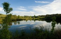
© Tamera Ecology Team
In the Tamera valley, new water retention landscapes were created to counter erosion, desertification, and droughts, combining interventions such as lake creation and reforestation. The eco-village of Tamera was involved and raised private funding to cover the high investment costs of the project.
Tamera, a farm of 154 ha, is located in the most arid region of Portugal (Alentejo). This area has shown significant trends of increasing erosion and desertification. Only a few decades ago, the Alentejo was a region where the streams flowed with water all year round, even in summer. Today the streams swell only during the rainy season and afterward they become dry again. The system has fallen completely out of balance and climate change is expected to exacerbate the situation. Tamera has managed to counteract erosion and desertification through the creation of a “Water Retention Landscape” (WRL) comprised of a system of lakes and other retention systems, and also including other structures such as terraces, swales and rotational grazing ponds. This approach to water management has created a regenerative basis for autonomous water supply, the regeneration of topsoil, forest, pasture and food production, and greater diversity of wild species. Currently, the Tamera project is in a process of restructuring, mainly in the areas of education, finances and networking.
Case Study Description
Challenges
Progressive desertification is currently one of the biggest problems in southern EU countries. In the Iberian Peninsula, especially in the south, decades of incorrect water and land use management have triggered a dramatic desertification process.
Alentejo is considered an arid region characterised by very hot and dry summers (maximum temperatures > 30° C) with long periods of no rain, reduced annual precipitation (average about 600 mm/m2ˑyear) and periodic droughts. The region is generally characterized by a high risk of desertification due to the present low quality of soils, land use patterns and its hot and dry climate. The erosion process has progressed so rapidly and extensively in this area that the humus topsoil has disappeared. This humus soil layer, which was shaded and rooted by plants, is fundamental to soak up the rainwater and thus to give the water time to seep into the deeper ground layers and fill up the underground aquifers. Moreover, it acts as a buffer contributing to prevent floods and to increased water quality in streams and aquifers.
Climate change is expected to further increase desertification in the area. The Mediterranean drylands have been identified as one of the most prominent regions affected by climate change in Europe in particular because of temperature rise. As reported in the Portuguese National Adaptation Plan (NAP), temperatures in Portugal are projected to increase from 2°-3°C (under the RCP 4.5, moderate emission scenario) up to 5°C (under RCP 8.5, the most emission climate scenario) by 2100, particularly during the summer season and in inland areas of the country. The pattern of precipitation shows significant reductions in annual values throughout the territory, under both RCP 4.5 and RCP 8.5; seasonal losses (in spring, summer and autumn) range from -10% to -50% by end of the century under the RCP8.5 scenario. Increase in heatwaves, together with a decrease in precipitation, envision a future of increased risk of desertification and biodiversity loss for most of southern Portugal. The projected increase in frequency and severity of drought events can strongly affect soil erosion, loss of top soil and nutrients availability. The reduction in precipitation will also affect aquifers recharging, increasing the degradation of the quality of surface and underground water resources. These issues are directly connected with the capability of ecosystems to deliver key services, such as water purification, and with agriculture productivity and human habitability of the southern Portugal.
Policy context of the adaptation measure
Case mainly developed and implemented because of other policy objectives, but with significant consideration of climate change adaptation aspects.
Objectives of the adaptation measure
The creation of a water retention landscape had the goal of counteracting the increasing trends of erosion, desertification and droughts observed in the area. This in turn has allowed Tamera to become self-sufficient in terms of water and food and to reduce its vulnerability to climate change and water-related extreme events such as droughts, water scarcity and floods. Tamera also aimed at demonstrating a model to be implemented in other Mediterranean areas prone to desertification.
Adaptation Options Implemented In This Case
Solutions
Water Retention Landscapes (WRL) are systems for the restoration of the full water cycle by retaining the water in the areas where it falls as rain. A WRL is a landscape with no rainwater run-off, where only spring water leaves the land. The rain which falls on such an area is taken up by the vegetation or the water-bodies and recharges the groundwater. The retention areas act in place of the fragile humus layer and, through their high water absorbing capacity, they also help to prevent fatal landslides and floods, which nowadays are caused more and more often by intense rainfall. There are many measures that can be used in various combinations to create WRLs (several of them have been used in Tamera as well):
- The construction of water retention spaces in the form of lakes and ponds;
- Reforestation and planting of mixed-culture ground cover vegetation;
- Holistic grazing management;
- Keyline design: a planning technique for maximizing beneficial use of water resources that considers topography and landscape features such as ridges, valleys and natural water courses, seeking optimum water storage sites and potential interconnecting channels;
- Terracing;
- Swales: low tracts of land, usually moist or marshy. Artificial swales are often designed to manage water runoff, filter pollutants, and increase rainwater infiltration;
- Infiltration of road and roof runoff water by different means.
Four elements are particularly important for the shaping of such water retention spaces:
- The vertical sealing layer of the dam (of a water retention space) consists of fine materials (ideally clay), usually using the material excavated from the deep zones. It is connected to a watertight layer of subsoil that sometimes lies a few meters below the surface. The sealing layer is compacted and built-up layer by layer with fine, earth-moist material. Then it is piled up from both sides with mixed earth-material, covered with humus or topsoil, and can then be landscaped and planted on. Through this natural construction method the water retention spaces fit in with the landscape and do not become incongruous with their surroundings.
- The longer side of the retention space is, if possible, laid out in the same direction as that of the prevailing wind. The wind then blows over a long surface, thereby forming waves which oxygenate the water: oxygen is an important element for the purification of water. Wind and waves carry particles of debris to the shores where they are trapped by aquatic plants and eventually absorbed by them.
- Banks are never artificially straightened or reinforced, but created in meandering forms with both steep and gently sloping parts so that the water can roll and swirl. At least one part of the shore is planted with aquatic and waterside plants.
- Deep and shallow zones are created. In this way different temperature zones emerge providing healthy thermodynamics in the water. Shaded shore areas support this process. Thus a diversity of habitats allow for a high diversity of aquatic organisms to be established.
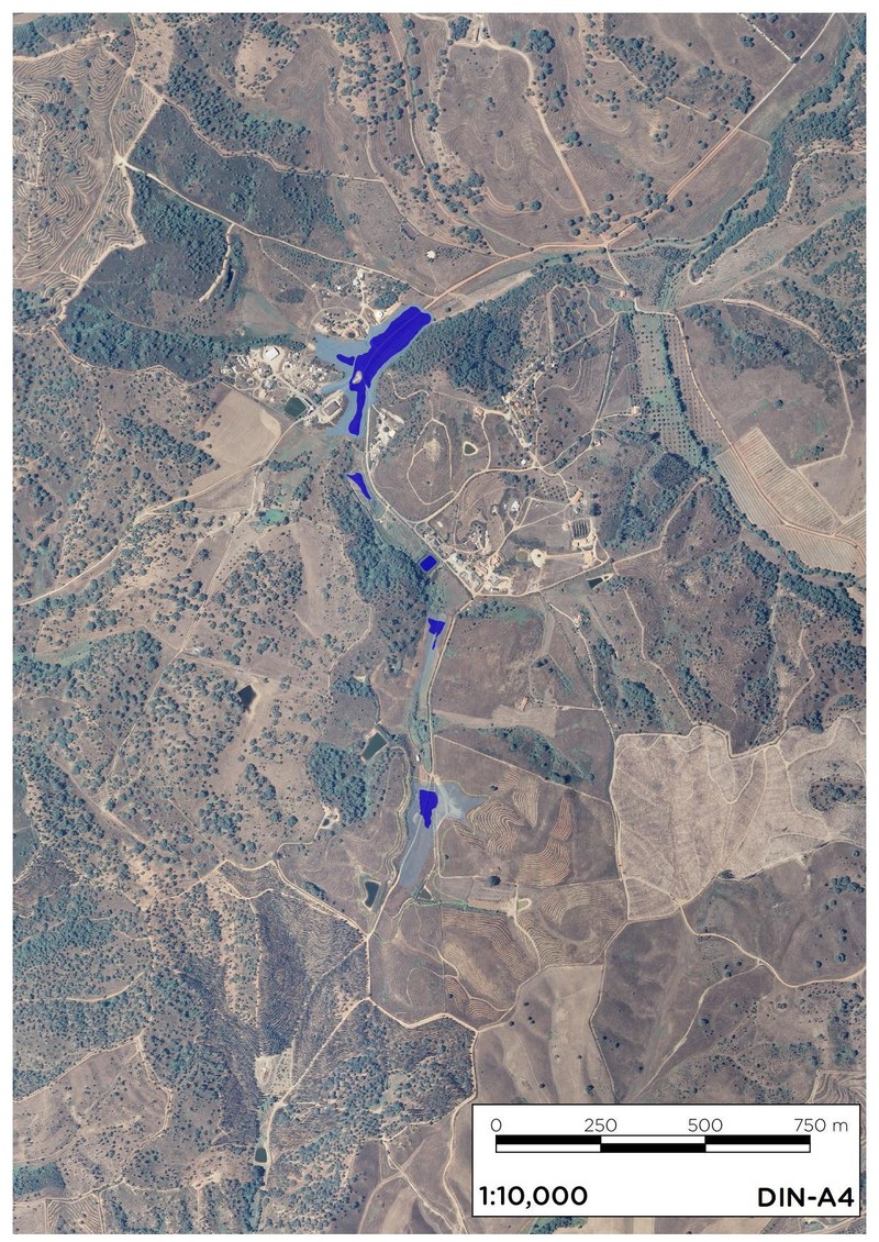
In Tamera, the creation of lakes has proven to be a faster and more effective method to reduce erosion than reforestation which is a much slower process. It was used as a first step to allow for reforestation to be done in the most eroded areas. A series of interconnected retention areas (from swale sized to pond-sized to lake-sized) were created using the local earth and stone material. The construction of the first water retention space, “Lake 1”, located in the centre of the Tamera site, was realised in 2007. “Lake 1”, with a total capacity of 6,400 m2, was totally filled during the second winter after its’ creation. Already within the first year a new seepage spring arose which since then has flowed continuously throughout the year from Tamera to the nearby farms. In 2011, another retention area, with about three times the capacity of “Lake 1”, was built.
From 2006 to 2015, 29 lakes and retention spaces were created and the area of water bodies was increased from 0.62 ha in 2006 to about 8.32 ha. After 2015, the efforts shifted from the construction of open water bodies and mainly focused to other interventions aiming to support water infiltration, vegetation growing and soil formation, such as swales, planting of ditches, mulching with wood chips and charcoal, and check and maintenance of dams.
Tamera is now prepared to fully absorb even strong continuous rainfall. This large retention area is located at the highest point of the valley. The water pressure is therefore high enough to irrigate all of the land, without additional energy needs for pumping. This highest-situated retention space can then provide enough water to maintain stable all year round the water level of the further down retention spaces. The water retention landscape creates space for riverside forest plants and fruit trees; in Tamera, chestnut, alder, ash and elder tree were planted. Forest corridors offer a protected path for wild animals to reach the lakes and ponds. Also, further away from the water bodies, olive trees, cork oaks and a huge variety of native trees were planted to increase diversity and productivity.
Additional Details
Stakeholder participation
The project was opened and discussed with the population of the region. Cooperation from neighbours has been important in several of the implementation stages. The on-going restructuring of the Tamera initiative is also focusing on improved education and networking.
Success and limiting factors
Financial investment needed to build the Water Retention Landscapes can be in the order of half a million euros and can represent one of the major obstacles to the implementation of this kind of measures. Regarding this obstacle, the ecovillage of Tamera used its communication and publicity capacity to raise private funding and donors to sponsor its vision.
The complex legal and regulatory framework represented another important obstacle.
Two success factors were considered particularly relevant for the adoption of the Water Retention Landscapes approach and the implementation of related actions in Tamera:
- the knowledge and information of the people responsible for designing the WRL, in particular to create landscapes adapted to the local climate;
- the capacity to convince and mobilize the ecovillage of Tamera to take on this multi-functional investment.
Costs and benefits
When the Tamera project started a cost and benefits analysis was developed. This assessment used the Net Present Value (NPV), which accounts for the sum of all discounted benefits for the analysis period minus the sum of all discounted costs in a single monetary common unit (Euro). The time period 2015-2050 and a discount rate of 3% were used in the analysis. The calculation of the total costs included: construction costs, licensing, fees and taxes. Other costs involved such as wellbeing reduction and pollution during the construction phases could not be accounted for. Identified benefits of the implementation of the WRL included:
- Increased carbon storage;
- Improved water quality;
- Benefits from increased number of visitors, in particular for water-related events;
- Reduced irrigation needs because the soil is saturated with water and the aquifers are filled;
- Social benefits (e.g. recreation value of the lakes; increase of the quality of life in the ecovillage);
- Agricultural benefits, including increased productivity, diversification of products and increased income;
- Reduced vulnerability to climate change effects, such as those related to increased drought frequency and intensity and reduced annual precipitation, as lakes provide good quality water to crops and livestock and reduce losses due to long droughts;
- Increased biodiversity, since the WRL creates a diverse set of habitats where wildlife species can live. It also acts in controlling pests and enhancing pollination;
- Stabilization of the groundwater table. Since 2011, the community of Tamera supplies all of its drinking water needs from wells that are fed by the Water Retention Landscape. Soon after “Lake 1” was created, a new spring appeared, feeding a small stream which flows from Tamera to the neighbouring land all year round. Thus, the lakes also support neighbours and firemen in times of drought or fire.
The economic assessment was done only for some of these benefits as some others could not be quantified. The quantified benefits were:
- Transitional woodlands increased from 9,34 ha to 19,50 ha mainly in areas previously occupied by natural grasslands. This lead to an overall increase in carbon storage of 9.4 %/year between 2006 and 2014.
- Estimated net income for 2014-2050 in tourism and water-related events such as the Water Symposium and the Permaculture Seminars is 810.000 €.
- The role of water in the landscape as a crucial element for social and environmental well-being and a thriving society, especially in semi-arid regions, was internalized by taking into account that the market valuation of land and the price elasticity of rural property is tightly connected with water availability, storage and water quality. Benefits were estimated between 150.000 € to 400.000 €.
The NPV regarding the variables and proxy’s considered resulted being negative (- 261.551 €), meaning that the high costs involved in the construction of the lakes are not overtaken by the discounted benefits, which would be a strong argument against the development of this type of projects. However, it must be acknowledged that slight changes in the discounting of benefits would have a major impact in the NPV.
Furthermore, and even more important, it must be taken into consideration that many of the benefits could not be quantified. One important variable which was excluded from the cost-benefits analysis due to lack of reliable data was the increased agriculture production which is expected to be very high. Also, the price of water is expected to increase over the next years and the value of resilient ecosystems will be much valued in such semi-arid regions. Because such projections are uncertain these have not been quantified.
Legal aspects
From a legal and regulatory perspective, it was important to specify that the new water bodies of the WRL are water retention spaces and not lakes.
In recent years, the regulation about fire prevention has become stricter, due to many devastating large scale fires (especially in Eucalyptus monoculture). As an effect, new measures (such as keeping humidity in the soil via mulching and chop-and-drop, good tree pruning practices, increasing diversity in areas with high fire risk, and community education and distributed responsibility) have been prioritized and implemented to make the Tamera area less prone to fire.
Implementation time
The design and creation of the Tamera water retention landscape started in 2006 and was completed in 2015. After 2015, activities have been mainly dedicated to the implementation of smaller interventions to support water infiltration, vegetation growing and soil building as well as to maintenance.
Lifetime
Lifetime can be in the range of 20 years or more, depending on management capacity and maintenance.
Reference Information
Contact
Christoph Ulbig
Coordinator of Education and Research
Tamera - Peace Research Center
Monte do Cerro, Portugal, 7630-303 Colos
E-mail: christoph.ulbig@tamera.org
Generic e-mail: office@tamera.org
Websites
References
Tamera initiative, Circle 2 Inspiration Book and BASE Project
Published in Climate-ADAPT: Jun 7, 2016
Please contact us for any other enquiry on this Case Study or to share a new Case Study (email climate.adapt@eea.europa.eu)
Case Study illustrations (5)
Language preference detected
Do you want to see the page translated into ?
Exclusion of liability
This translation is generated by eTranslation, a machine translation tool provided by the European Commission.