All official European Union website addresses are in the europa.eu domain.
See all EU institutions and bodies
An official website of the European Union | How do you know?
Environmental information systems
EN

The Drents AdaptatieBeeld is a platform for anyone who wants to learn more about climate change and adaptation in Drenthe. The story maps visualise the potential effects and impacts of climate hazards on the Dutch province.
Key Learnings
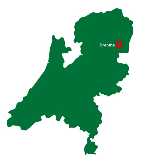
About the Region
Climate Threats
Climate change poses multiple challenges in the Dutch province of Drenthe. Despite getting drier and warmer, with an average temperature rise of 1.1°C over the past three decades, there has been a notable increase in rainfall, often extending over longer periods. The StoryMaps illustrate the most important current and future climate impacts on Drenthe, advocating for appropriate measures to be taken.
Currently, summers typically experience four tropical days, with temperatures surpassing 30°C. By 2050, this figure could potentially rise to a range of 6-10 tropical days. While dry summers contribute to a reduction in average precipitation, there are forecasts of localised disruptions featuring heavy rainfall. Projections indicate that by 2050, extreme rainfalls with 70mm per hour will occur twice as often as today (currently every 100 years). Despite less rain on average coupled with increased evaporation, overall conditions are expected to become drier, leading to declining groundwater levels.
Soil subsidence 2020-2050
In the Netherlands, fluctuations in groundwater levels are common and lead to subsidence - sinking of the ground because of underground material movement - a phenomenon that can be exacerbated by human activities. Drainage, for example, causes peat oxidation and consolidation, and oil and gas extraction leads to pre-exposure during site preparation. Climate change can also accelerate the process of soil subsidence, as severe weather events can cause fluctuations in groundwater levels. In Drenthe, the stream valleys and the Southeast of Drenthe are particularly prone to subsidence.
Subsidence can cause damage to buildings, roads, bridges, sewage systems, cables, and drainage. Uneven subsidence can cause flooding and increase potential flood depths. Peat oxidation also leads to CO2 emissions and reduced water quality. In the Netherlands, the drainage of peat meadows annually leads to CO2 emissions of 5.6 million tons of CO2 equivalent.
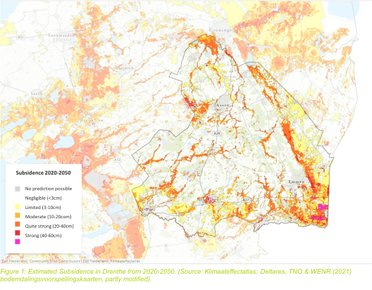
Figure 1: Estimated Subsidence in Drenthe from 2020-2050. (Source: Klimaateffectatlas: Deltares, TNO & WENR (2021) bodemdalingsvoorspellingskaarten, partly modified).
Risk differences due to construction
Before 1975, many buildings were constructed on timber, or so-called “on steel” foundations. Both types can be vulnerable to damage when the subsoil contains peat or clay. Buildings can sink unevenly due to changing subsoil compositions, uneven weight distributions, or a weak foundation. Consequently, buildings tilt, and damages occur. Climate change can aggravate the threat of subsidence, as drought conditions can accelerate soil sinking and cause deeper clay layers to shrink and swell.
Therefore, soil subsidence can become a costly issue. Factoring in climate change, potential foundation damage costs in the Netherlands could range from 8 to 54 billion euros.
As part of Drenthe’s Adaptation Picture (DAB) the risk map (Foundation risk map - Klimaateffectatlas) indicates the risk of construction on steel due to subsidence by 2050 considering both weak and strong climate change scenarios. The differential risk map comprises two underlying maps. The maps in the Climate Impact Atlas provide a prediction of soil subsidence in the Netherlands based on the following causes:
• Drainage of slack soil
• Mineral mining
• Taxing soft soil
These three causes represent major risks for the infrastructure and the economy of the region.
Water supply from IJsselmeer
In dry years, Drenthe depends on surface water supplies from the IJsselmeer. During drought periods, the demand for water from IJsselmeer increases for the North of the Netherlands, potentially leading to a water shortage in the IJsselmeer region. Consequently, existing management measures may prove insufficient, requiring reductions in the IJsselmeer region's water usage. As many people are unaware of this problem, the tool provides information about the water supply to enable behavioural changes in the local population in Drenthe.
Maps and data
The Maps and data show the risks of flooding, drought, and other climate change impacts in Drenthe. This information can be taken and translated into adaptation measures to reduce those risks. For instance, the construction of flood defences, wetland restoration, and a shift in land use can mitigate the impact of climate change. The tool also provides expertise and advice on climate change adaptation. Furthermore, the platform is a gateway to other resources on climate change adaptation, such as governmental websites and scientific reports. Henk Jumelet, Executive Board Member for the Province of Drenthe, describes the platform in one of his statements.
The platform provides access to knowledge and information to help us better understand what climate change means for Drenthe, and to guide our choices regarding the environment, for now, and for the future. The tool facilitates discussions regarding the effectiveness and necessity of environmental measures.
Henk Jumelet, Executive Board Member for the Province of Drenthe
Examples of information on the Drents AdaptatieBeeld
- Maps of flood risk: The platform provides information about the areas of Drenthe that face the highest risk of flooding due to high river levels, heavy rainfall, and storm surges. These maps can be used to identify areas where flood protection is necessary and help plan measures to tackle future flooding events.
- Information on drought risk: The platform also includes information about the drought risk in Drenthe including maps of the areas with the highest risk, as well as information about the impact of the drought on agriculture, water resources, and the environment.
- The maps provide information on the climate impacts of different sectors that are important for the province of Drenthe. For example, agriculture, the built environment, recreation etc. The maps show the different effects of climate change on these sectors and elaborate on their impacts.
Conclusion
In conclusion, climate change presents significant challenges for the Dutch province of Drenthe. Despite experiencing increasing dryness and warmth over the past three decades, accompanied by a notable rise in average temperatures, there has been a concurrent increase in rainfall, often occurring over extended periods.
The StoryMaps effectively illustrate the current and anticipated climate impacts on Drenthe, highlighting the urgent need for appropriate measures to be taken. As summers are projected to become hotter and potentially more unpredictable, with an increase in both dry spells and heavy rainfall events, the region faces heightened risks of drought, flooding, and soil subsidence.
Ultimately, the Drenthe's Adaptation Picture (DAB) is a vital resource for decision-makers, enabling them to navigate the complex challenges of climate change and soil subsidence in Drenthe. By leveraging the information and tools provided by the DAB, the province can proactively anticipate risks, enhance resilience, and safeguard its communities and environment for generations to come.
Summary
Further Information
Contact
Climate Impacts
Adaptation Sectors
Key Community Systems
Countries
Funding Programme
Disclaimer
The contents and links to third-party items on this Mission webpage are developed by the MIP4Adapt team led by Ricardo, under contract CINEA/2022/OP/0013/SI2.884597 funded by the European Union and do not necessarily reflect those of the European Union, CINEA, or those of the European Environment Agency (EEA) as host of the Climate-ADAPT Platform. Neither the European Union nor CINEA nor the EEA accepts responsibility or liability arising out of or in connection with the information on these pages.
Language preference detected
Do you want to see the page translated into ?
Exclusion of liability
This translation is generated by eTranslation, a machine translation tool provided by the European Commission.
Exclusion of liability
This translation is generated by eTranslation, a machine translation tool provided by the European Commission.