All official European Union website addresses are in the europa.eu domain.
See all EU institutions and bodies
An official website of the European Union | How do you know?
Environmental information systems
EN

Adapting a World Heritage city in Salamanca (Spain) to climate change through a green corridor and promoting a new concept, called “green heritage”.
Key Learnings
About the Region

Climate Threats
According to future projections, temperature increases, and heat waves represent the greatest climate threats in Salamanca. The risks include decreased water reserves, droughts, increased morbidity and mortality - particularly in vulnerable groups - extreme precipitation events and increased energy consumption with associated risks of overload and distribution issues. These risks can negatively affect tourism, crucial in a city like Salamanca, recognised as a World Heritage site.
Context
As a pilot initiative, the project will establish a green infrastructure network to enhance climate change adaptation in Salamanca. It will develop a green corridor through 7 km of an old livestock route, “Via de la Plata”, that crosses Salamanca from north to south. The Urban Adaptation Support tool is used as a guideline, comprising several steps, such as vulnerability and risk assessment, defining local climate zones, identifying and prioritising adaptation options, defining a roadmap and implementing nature-based solutions.
Machine learning for climate zone assessment
Machine learning assessed local climate zones to help planners and managers cope with the local hot spots (heat island effect). The key objective was to identify areas with different microclimatic conditions to plan for effective adaptation measures. The methodology efficiently identified local climate zones by detecting areas with distinct building densities, vegetation levels, and temperature variations. The results revealed differences in average and minimum temperatures across the local climatic zones during the summer months.
It should be noted that the analysis has not fully differentiated the historical area from more contemporary sections; specifically, the historic areas are categorised within the same zone as the modern expansions. This implies that their characteristics are similar from a climate diagnosis perspective. However, regarding adaptation, the heritage area requires specific measures and presents different conditions compared to the rest of its climate zone.
For instance, attention must be given to ensuring that exterior finishes on pavements and walls are compatible with historical assets, their preservation, and their appreciation. It is also crucial to guarantee that vegetation does not cause structural damage or worsen humidity conditions while allowing for its visual appreciation.
The value of heritage is independent of its behaviour against the heat island effect as it is grounded in cultural rather than physical aspects. Other conditions, such as building density and the presence of vegetation, lead to the appearance or decline of the heat island effect in the city, where identification of appropriate climate-resilient solutions is key.
Methodology
The pioneering nature of the study has been not so much to propose a replicable methodology of urban analysis based on satellite data, but rather to combine it with other open variables, such as those from the Buildings and Cadastral Parcel of the INSPIRE directive. The final variables used in the model presented are:
i) Built area above ground level
ii) Area occupied by buildings
iii) Residential area per cadastral plot
iv) Cadastral plots area (these four categories obtained from INSPIRE data)
v) NDVI Vegetation Index (derived from COPERNICUS-Sentinel 2 data)
vi) Soil impermeability index (COPERNICUS data), and
vii) Surface temperature (Landsat 8 USGS data).
The integration of these layers of information is done by machine learning, specifically with unsupervised algorithms. The selected algorithm to digest these data was Kmeans, due to its versatility and adaptation to the case, also being easily accessible through open libraries. More information here.
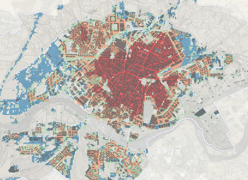
Figure 1: Local climate zones in Salamanca

Tool for prioritising adaptation measures
The project identified 110 adaptation measures of different types (e.g., green, grey and blue infrastructure, social, management, etc.) and main related sectors. After characterising these measures, a tool for prioritising adaptation measures was developed and made public online. This prioritisation tool is based on a multi-criteria analysis that provides a systemic and structured approach to evaluate options that meet different criteria.
In the case of Salamanca, the selected criteria are 1) reduction of climate change impacts; 2) technical and economic viability; 3) improvement of the provision of ecosystem services; 4) maintenance of the cultural heritage; and 5) reduction of impacts to population, particularly to the most vulnerable. Each adaptation measure was scored against these criteria.
Next, the five criteria were weighted to reflect the relative importance of one criterion to the others through a survey and a participatory workshop involving staff from several municipal departments. This process helped to disseminate the list of measures and key adaptation options among the city managers and decision-makers and create bigger ownership of the plan and the city's adaptation efforts.
Adaptation of heritage environment
The adaptation of heritage is tackled from two perspectives: firstly, from planning and compiling a series of measures and strategies and secondly, through the implementation of nature-based solutions.
As part of the city's adaptation roadmap, a proposal has been suggested to create an adaptation guide for historic buildings in Salamanca. This guide aims to assess the future scenarios of these buildings, focusing on preservation and ensuring habitable interior conditions. It is important as the materials used in vernacular architecture (such as the Villamayor stone) and the climate conditions are specific to this context, and therefore require tailored solutions. The guide should also explore asset-friendly renovation solutions, adaptation to new uses, legislative framework, etc.
In addition, a proposal is made to develop a recovery plan to rebuild better, which serves to recover assets following a disaster or extreme event. Rebuilding better not only means rebuilding what is damaged, but also adapting and rethinking the asset in a way that contributes to achieving greater resilience. Furthermore, renovating highly exposed assets that are repeatedly damaged must be economically considered.

Figure 2: Soil permeabilisation around the Santiago church
Regarding the implementation of nature-based solutions, the objective was to increase the greening of public spaces through different actions such as green façades, expansion of soil permeabilization (Figure 2), tree pits (Figure 3) and installation of draining ditches (Figure 4). The challenges encountered are technical, bureaucratic, and legal. At a technical level, the actions on historic streets where the facilities are not registered and where there may be archaeological remains, presented many problems, incompatibility with the plantations and delays. It seems that comprehensive interventions of entire streets are preferable, as they allow the design to be adjusted to the state of the subsoil.
Additionally, for heritage areas, noble materials are demanded, which can increase costs. Legally speaking, protected areas and buildings present a series of strict regulations that must be met, leaving little possibility of action, and at a bureaucratic level, obtaining permits can suppose a delay of several months.
Finally, coordination between different departments involved (heritage, urban planning, civil infrastructure) presents another challenge. Nevertheless, this experience has trained municipal technicians to carry out innovative actions, overcoming challenges and learning from difficulties, ultimately achieving good results.

Figure 3: 4 Linear extension of a tree pit

Figure 4:3 Greening of the city walls surroundings
Summary
Further Information
Contact
Climate Impacts
Adaptation Sectors
Key Community Systems
Countries
Funding Programme
Disclaimer
The contents and links to third-party items on this Mission webpage are developed by the MIP4Adapt team led by Ricardo, under contract CINEA/2022/OP/0013/SI2.884597 funded by the European Union and do not necessarily reflect those of the European Union, CINEA, or those of the European Environment Agency (EEA) as host of the Climate-ADAPT Platform. Neither the European Union nor CINEA nor the EEA accepts responsibility or liability arising out of or in connection with the information on these pages.
Language preference detected
Do you want to see the page translated into ?
Exclusion of liability
This translation is generated by eTranslation, a machine translation tool provided by the European Commission.
Exclusion of liability
This translation is generated by eTranslation, a machine translation tool provided by the European Commission.